Theme 3: GPS Technologies
Dr. Pearson has worked to develop novel GPS-based, viewshed and imagery techniques to quantify visual exposures.
She has used automated and 360 camera imagery to assess visual exposures of the built environment including food and alcohol marketing
and tobacco signage.
Using linked GPS and automated camera imagery to understand children’s visual exposures
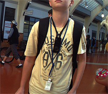 For example, in one study called KidsCam (PI: Louise Signal), Dr Pearson and colleagues linked GPS data and
automated camera imagery to assess what New Zealand children see in their everyday lives.
For example, in one study called KidsCam (PI: Louise Signal), Dr Pearson and colleagues linked GPS data and
automated camera imagery to assess what New Zealand children see in their everyday lives.
Images were coded for content, including unhealthy food marketing and alcohol marketing but also positive visual exposures including blue spaces (i.e., water bodies such as the ocean).
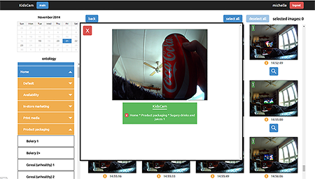
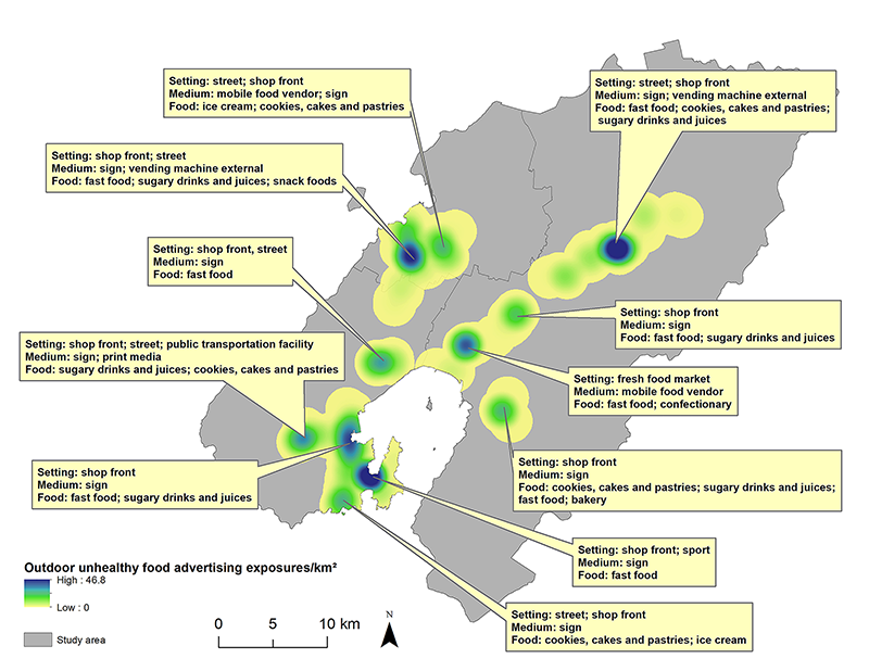
Then, using the linked GPS and food advertising image codes, we were able to quantify hot spots of exposure to unhealthy food advertising. We used this spatial data to test the effectiveness of a suite of policy options to ban unhealthy food advertising in outdoor spaces.
Using viewshed analyses to quantify visual exposure to health-related behaviors
 Because seeing others engaged in health-related behaviors affects our
perception of the normality of those behaviors (i.e., normalization, or social contagion), it is useful to be able to quantify those visual exposures. These
behaviors may be health-promoting (e.g., jogging or walking in the neighborhood) or health-hindering (e.g., smoking in public places). Geographic techniques,
including viewshed analyses, allow us to quantify such visual exposures.
Because seeing others engaged in health-related behaviors affects our
perception of the normality of those behaviors (i.e., normalization, or social contagion), it is useful to be able to quantify those visual exposures. These
behaviors may be health-promoting (e.g., jogging or walking in the neighborhood) or health-hindering (e.g., smoking in public places). Geographic techniques,
including viewshed analyses, allow us to quantify such visual exposures.
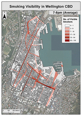
In Wellington, New Zealand, Dr. Pearson and colleagues collected observations of active smoking across the central business district at various times of day. These data were then used, in combination with data on visual obstacles including building footprints, to quantify areas where people may be exposed to different levels of visual smoking.
Developing novel GPS devices and GPS data processing tools to objectively measure health-related behaviors
 Over the past 12 years, Dr. Pearson has been investigating water
security issues in south-western Uganda’s semi-arid savannah. Her research has shown that households often use unreliable, contaminated surface water sources following land use policy changes
that limit access to large, permanent water sources (i.e., lakes). Due to water insecurity, residents may sneak, borrow or purchase water or illegally migrate
in order to cope. Water source usage also appears to change dramatically across seasons, with critical health
(including stress) implications.
Over the past 12 years, Dr. Pearson has been investigating water
security issues in south-western Uganda’s semi-arid savannah. Her research has shown that households often use unreliable, contaminated surface water sources following land use policy changes
that limit access to large, permanent water sources (i.e., lakes). Due to water insecurity, residents may sneak, borrow or purchase water or illegally migrate
in order to cope. Water source usage also appears to change dramatically across seasons, with critical health
(including stress) implications.
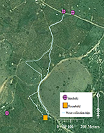
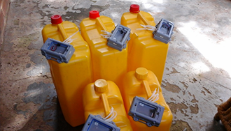 To better understand the changes in household water insecurity across
seasons or even weeks or days, Dr. Pearson developed novel methods to assess the fine spatial and temporal scale of water collection. That is, she designed and published one of the first methods to objectively measure behavior rather than using self-reported water data. To accomplish this,
she collaborated with engineers to develop a novel GPS unit that affixes to a jerry can (used for water collection). The GPS unit was field-tested and compared to self-reported and
commonly used spatial measures. Her research showed that most households collected water from multiple sources, not always a groundwater source or nearest
their home. These findings, while preliminary, call into question many of the conventional metrics of household water availability. Moreover, these
contributions advance geospatial research via the development of a novel GPS technology, which allows us, for the first time, to objectively monitor day-to-day
changes in water collection behaviors.
To better understand the changes in household water insecurity across
seasons or even weeks or days, Dr. Pearson developed novel methods to assess the fine spatial and temporal scale of water collection. That is, she designed and published one of the first methods to objectively measure behavior rather than using self-reported water data. To accomplish this,
she collaborated with engineers to develop a novel GPS unit that affixes to a jerry can (used for water collection). The GPS unit was field-tested and compared to self-reported and
commonly used spatial measures. Her research showed that most households collected water from multiple sources, not always a groundwater source or nearest
their home. These findings, while preliminary, call into question many of the conventional metrics of household water availability. Moreover, these
contributions advance geospatial research via the development of a novel GPS technology, which allows us, for the first time, to objectively monitor day-to-day
changes in water collection behaviors.
Using big imagery data (Google Street View and Google Earth) for health research
Many health researchers are making use of large spatial and imagery data as it becomes increasingly available. Dr. Pearson and colleagues have reviewed the use of these data in health research generally, and also in relation to tobacco issues specifically. Most studies use platforms such as Google Street View to conduct neighborhood audits of features which may be related to health (for Dr. Pearson’s research on neighborhoods and health, click here). This is particularly helpful, as the images are taken at about eye-level, giving one a sense of visual exposures from a human perspective.
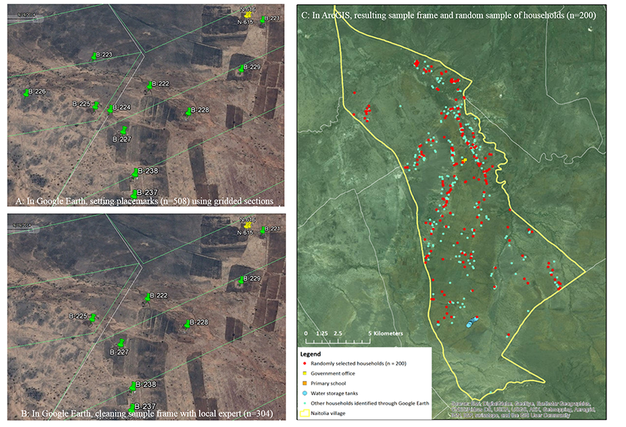
Platforms like Google Earth involve aerial imagery and can also be used in health research. For example, Dr. Pearson and colleagues used Google Earth to develop a random sampling scheme for households in rural Tanzania. Because address and street data were non-existent and because agro-pastoral communities in the region live in dispersed patterns, other forms of sampling were suboptimal or impossible. They used Google Earth to quantify households, assign random numbers and then generate a sample for a health survey. These home locations could also be used when deploying the field team to collect the data on tablets.